And then a few minutes later the storm hit…..
Sometimes the trail can be difficult to find but it’s almost always a rewarding search
10
10
And then a few minutes later the storm hit…..
Sometimes the trail can be difficult to find but it’s almost always a rewarding search

Rainbows Without Borders

So, we’re all standing around in the evening near South Pond in Bosque del Apache NWR waiting for the Sand Cranes to return from whence they departed earlier in the day – way earlier!
We waited. And waited. And waited. But instead of the thousands that had taken off earlier, we had tens trickling back in. And then the train came by.

The sun set. The moon rose. And a few of the cranes graced the horizon
A few shots from Chiricahua National Monument near Willcox, AZ.

Sunset from Massai Point
I do way too many sunsets but from time to time I’m confronted with one that just keeps on giving. I was sitting on the beach with Lisa and Mike when this one offered up a seeming unending number of visuals.

The Largo 4

The Largo 4

The Largo 4

The Largo 4
Caught this on the expanse between Tallahassee and Panama City, Florida. It was a battle between me and the mosquitoes but I think I won.


The Grotto at South Tufa, Mono Lake in the Eastern Sierras
I was first introduced to the Mono Lake Basin in September 2011 on a trip with my son Charles and his Green Tortoise Travel bus and have since had the opportunity not only to spend a lot of time exploring there, but more importantly to become acquainted with and a part of the Mono Lake Committee, a conservancy organization co-founded by the late David Gaines that has been in operation at ML since the mid-80’s. It’s very safe to say that lacking the efforts of the MLC there would be no Mono Lake today. It would have long since gone the way of Owens Lake a little further south of the Basin. Owens, despite its ‘lake’ designation, is now a very large salt flat: Picturesque. Toxic.
Not so Mono Lake, which even bearing a salinity level exceeding twice that of the Pacific is one of the liveliest (and loveliest) bodies of water on earth. It plays host to trillions of brine shrimp which control the lake’s algae levels and provide a critical food source to the millions of migratory birds that use Mono Lake annually. The shrimp are also a staple for about a third of the world’s California Gull population that calls this place its nesting home.

Pastimes
I became a volunteer with the Committee this past spring and commuted up from Los Angeles over a period of several weeks to get the training necessary to the work and then to actually deliver on that investment before leaving for the east coast in mid-July. The photographic materials piled up and for the most never got posted so I thought I’d better do something about that before it slipped away entirely. I’ve culled through my logs and come up with a couple hundred shots. It’s overkill I suppose but does offer a reasonably good view of my activities over these many months. It also includes shots of the volunteer group I was a part of, led by a very dedicated former California State Park Ranger, Janet Carle. Janet, and her husband David, also a former ranger at Mono Lake, have published a book entitled Traveling the 38th Parallel which ties together global water issues common to the latitudinal band that intersects the Mono Basin. Well worth looking at.
And Mono Lake is well worth visiting. If you find yourself traveling to Yosemite or anywhere in the Eastern Sierra area you’d be well rewarded making the trip to the Lake, to the Bodie Hills and Mono Craters and to the little town of Lee Vining hard by the shoreline. If you happen there next spring look me up. I’ll be the guy hanging around the Old Marina on the west end sporting a Mono Lake Volunteer vest and a spotting scope to keep an eye on the Osprey that nest in the towers. Be happy to give you a tour. By next year I might even be able to name a few of the other species that call this place home.
It started raining just after midnight and hasn’t ceased or even slowed since – has me pinned in my tent pondering the rain gear stored in the car.
Rain of this magnitude – it’s really pouring – is a normal occurrence in the Mid-Atlantic region though usually not this early in the season. Trees begin storing water in the fall to create the sap necessary to get them through winter. But early fall is six weeks off. I keep thinking as I lay stretched out here on my sleeping bag how welcome this rain would be in the Eastern Sierra – Mono Lake especially comes to mind. But if I’ve learned nothing else out here it’s that Nature is what it is; fiddling with it can be problematic. Adjusting is a better approach. As Charles says ‘It’s never a matter of wrong weather just wrong kit.’ In this case it’s right kit; wrong storage location. And a soaking trip in between.
When I arrived in Shenandoah National Park yesterday, after completing the three day run of the Blue Ridge Parkway, the sky was near crystal clear. Very unusual here where a haze is almost constantly present from the summit of Skyline Drive out across Shenandoah Valley. Not yesterday afternoon. Visibility was excellent, better than I’d ever remembered from my many trips here over the years. I immediately anticipated a grandelicious sunset. That was around 1400.
But there was rain to the south headed our way. I believe there’s something called a Tropical Depression running round the Gulf so this might be a result of its presence. This is the early edge of hurricane season in that area which tends to frequent rain in this area. (Rain is much more welcome than a hurricane.) Anyway, as the clouds rolled in about 1600 my hopes began to fade. But I thought there might be a chance so, after getting camp set up and grabbing a couple of Reese Cups and a bottle of Gatorade for dinner at the camp store, I drove the ten miles or so south to Turk Mountain Overlook and took up the vigil, camera at the ready.
Didn’t happen.
What you see, compliments of iPhone, did.

What you don’t see is my hesitance to open the tent flap and make a dash for the car to retrieve the gear I should have placed in the tent last night. I’m sure I’ll rally soon. In the meantime I’ll enjoy another chapter of Twain’s Roughing It<a
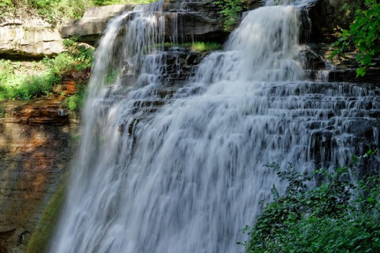
I had the opportunity to visit Cuyahoga Valley National Park last week and its Brandywine Falls of which I had snapped an iPhone photo and posted on Facebook. It received quite a bit of positive feedback so I thought you might also enjoy one of the photographs I captured with my Canon DSLR.
I suppose the real cause of my all night drive from Pictured Rocks National Seashore resulted from my dalliance along the Au Sable Point Trail. I had seen the Au Sable Light from a vantage point along the dunes about five miles north near Grand Marais and decided I needed to get a closer look. It’s reached by a trail located just off the north perimeter of the Lower Campground, about a mile and a half from the lighthouse, so when I finished up tramping around the dunes I drove down that way.
By the time I reached the trailhead it was 1930. I calculated the walk would require 30 minutes one way and given that I’m still way north (46 degrees) I’d have plenty of time to get out there do some photography and get back before dark. I was thinking about the Light not the sunset and relished the idea that for once I would be approaching my subject both at the right time of day and under near perfect weather. One of those rare times when my schedule coincided with the right everything.
The Lower Campground is hard by the lakeshore. I parked and proceeded up the path. It runs parallel to the and within feet of the shoreline providing a panoramic view of Lake Superior. As I trudged along it occurred to me that in addition to the Lighthouse I might also be able to capture shots of the sunset over the lake.
I took my time at the Light and shot it from as many angles as I could. It has stood on the point since 1874 and is one of tens such lights found around the Great Lakes area. If you’re into light houses this is the place to be – much more so than on the east or west coastlines. The shots will be the subject of the next post because I was more taken – at least for now – by what followed that part of the shoot.
I finished up, working my way around a few late evening visitors who arrived in time to clutter up the view, and headed back down the trail at a quick pace. I planned on finding a spot on the beach near where I had parked the car and taking in the ending of the day. I arrived about 2030 and looked around for a spot. It was then I also realized that I had plenty of time to run and get my tripod – always a last-minute and usually overlooked thought – as well as a lens filter that would help to cut the sun’s glare and capture more of its coloration. So I picked the items up and headed back to the beach.
I was surprised to see that just left of the place at which I entered the beach a creek was flowing into the lake at moderate to high velocity so I settled on a spot that placed its exit point between me and the sunset. The lens filter ( a variable Tiffen) allowed me to soften the sun’s rays and to slow the movement of the water. I really loved the results.
Click on the photograph to see the several different shots that are in the SmugMug Gallery


I’ve come to find that Groupons lead me to places I might otherwise not find, or not find so easily. That’s certainly the case with South Coast Botanic. It popped up on a daily deal a couple of weeks back offering a one year family membership for $20. I’ve really come to enjoy visits to botanic gardens and arboretum so I took the deal.
It was a very good decision. For one, as you’ll see, this is an extremely well-presented garden and well worth the price of admission. As it is that $20 will allow for visits throughout the seasons – such as they are here in SoCal – for the next twelve months.
And a Bonus! It seems there are 23 reciprocating gardens located here in California and over a hundred throughout the country. My membership is good for all of them. If you’re in the area you might want to look into this. With or without a Groupon it’s hard to beat.
International Readers: Google “Groupon” 🙂
One of the things I had been looking forward to on my recent camping trip to Death Valley – also my first visit – was seeing the night sky from one of the darkest places on earth. Being an eastern urbanite that sky is something that I am otherwise routinely deprived of. I wasn’t fully aware of the depths of my deprivation until one summer night sitting outside my dwelling in Arroyo Seco, near Taos, I glanced up and really saw the Milky Way for the first time. It was almost as if I were looking at the underside of a very sparkly lid – it was that tangibly imposing to me. I had been in a few planetariums in my life and in a few dark areas; but nothing I ever saw displayed in any of them came close to looking at the real thing hanging there over my head that night. So, I figured this would be one of the many treats to expect in the Valley. A super dark sky and a big ol Milky Way.
Typically, I paid no attention to the state of the sky before arriving. I just go. I thought I would see exactly what I intended to see: A gazillion stars spread out endlessly across the night sky. The moon had different plans and for most of my stay was up early shining like a flood light and not setting until late the next morning. But even had I done the research ahead of time my visit schedule wasn’t going to change. Fortunately I’m going to be under wide open western skies for some time and the Valley is only a short 5 hour drive from my base camp in Los Angeles. There will be other chances, assuming the Mayans weren’t hiding the real date somewhere.
I went with what I had and since I had to be up early for sunrise lighting I was also able to get moonsets. I suppose I could have done the moonrise but when it’s full like this it’s very difficult to acquire any contrast on its face and a moon without contrast just looks like – well, a big flood light. Nothing especially interesting about that.
I already posted one of my Zabriskie shots on Google+ in the Death Valley Photographers Community – a part of which I now count myself, but nothing’s come through the blog yet so here you have a sunrise scene that I took from the top side of the Texas Springs campground area – nice when the shots come to you – and then a shot of the moon setting on the western side of the Valley over the Panamint Range. These were shot on different days because the sunrise shots I got from the Zabriskie overlook just didn’t work. (I feel as if I’m lucky when any of them turn out.)

I also have to admit that this sunrise caught me by surprise. I was a little late getting out of the tent on this morning and hadn’t expected to see anything other than a bright morning sky. The gear was locked in the car. The camera had no lens mounted. So I had to scramble. Hand held. The shutter was a little on the slow side to get the image and it suffered as a result from a lack of sharpness. But still. I can’t remember the last time I saw so much sunfire in the morning sky. It is what it is. And that ‘is’ works for me.

I was more prepared for the moonset and I like the result. The geology and the astronomy that manifest their ways in Death Valley make it a wondrous place. This Valley certainly earned its name. It holds the bones of many men and animals who arrived in its depths at the wrong time and became permanent footnotes in its long and violent history. Even today taking anything in this place for granted can cost you your next sunrise – all your next sunrises. No matter. It is a visual delight and one of the grandest exhibitions Nature puts on anywhere on earth.
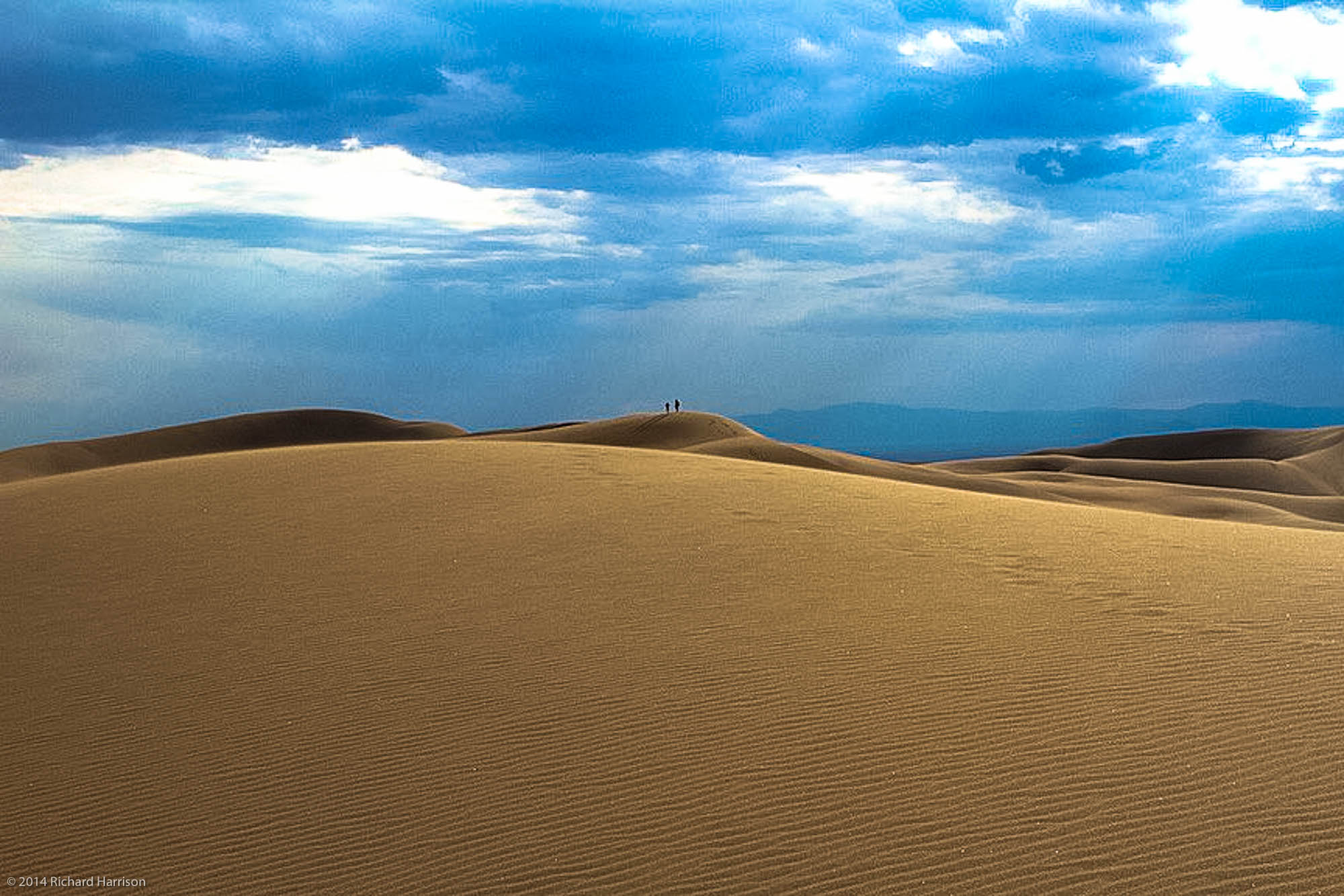
Since I’ve been recalcitrant in getting any of the première shots online let me add one more; this of the Mesquite Sand Dunes near Stovepipe Wells. I’m sure as people make return trips to DV that favorites places established in earlier visits become replaced by new ones that hadn’t quite resolved for them earlier. This place is simply too grandiose (is that redundant?) for anyone to make a selection for all time. But they can one at a time – and I did. The Dunes. They are mesmerizing. They are also easy to get lost in if you fail to hold the high ground. I posted a couple of videos on Facebook of my walking round these piles of sand and acquired a pretty spiffy self-portrait that is posted in the Selfy-Sunday Group on Google +. This shot is my favorite – so far. It’s a soft exposure and I just like the way so many of the colors that define this place blend together in it.

This was taken late morning and so the light here is also from the sunrise. The area in the foreground I think is referred to as The Devil’s Corn Field but I’m not entirely sure. If it weren’t so late and if I weren’t so lazy, I’d look it up. As it is, if you’re really curious – or perhaps know – you can chime in.

Sunset over Lone Pine, CA and Lake Owens as seen from the Whitney Portal

