Autumnal Horizons

The trip between Missoula and Post Falls was remarkable for its display of autumn colors which are as vivid in the west as they are in the east and perhaps more striking because of the vast spaces that spread out in between. This was one of my favorites taken between West Glacier and Coeur d’Alene.

10

Mt Cadillac

Mt Desert Island, ME. Looking east across the top of Mt Cadillac about an hour after sunrise.

10

Otter Creek

Acadia  1094 by RichardGHarrison
Acadia 1094, a photo by RichardGHarrison on Flickr.

Mt Desert Island

10

Tacking

Acadia  1104 by RichardGHarrison
Acadia 1104, a photo by RichardGHarrison on Flickr.

Northeast Harbor, Mt Desert Island

Olympia

Olympia, a set on Flickr.

The path from the Olympic Peninsula to Mt Rainier passes right through Olympia, the state Capitol. I thought I’d see how it compared to Bismarck.

No contest. The Capitol Campus as it’s called here is awesome. Sits on a beautifully landscaped hill overlooking the Port of Olympia and incorporates the architectural norms I would expect to find. Puts that pile of concrete and glass in Bismarck to utter shame.

10


Peninsula Camp


Peninsula Camp, a set on Flickr.

Coming to you tonight from the Hobo Inn about 10 miles east of Mt Rainier. A leisurely days journey from the campsite I’ve occupied on the peninsula for the past three days. And a little, though not a lot, warmer. Temps dropped to 34 last night pushing a few degrees past my limit but when you’re in, you’re in. I survived. Maybe I need to adjust my bar some. I’ll do some stuff for you on Rainier tomorrow. For now a few pics from Olympic. These are all iPhone shots.

I camped at Mora campground on the west central area of the coast park. Had expected to be the only camper around it surprisingly the place was almost full. Lots of fishermen for the most with a few hardy hikers here and there.

I discovered quickly that clear weather was to be had in the morning so was up and out at the first sign of light. I’m still somewhat on east coast time so the early rise was not problematic. Only one good sunset shot.

Really enjoyed this park and got my first extensive experience with rain forests, after the brief encounter in the Cascades. Lesson learned: it’s probably best to visit a rain forest outside the rainy season. I had all the gear I needed for the venture but despite the weatherization of my Canon equipment the camera body grumbled and threw a couple of short-term feature outages at me. I soldiered on and made use of the air drying machine in the camp latrine.

All the water aside I think the shots ingot in the Hoh Rainforest area are the best of the trip to date. Not included in this post but I’ll get them up soon. They have an absolutely surreal aura to them.

In the meantime enjoy the camp and beach shots. More to come.

Hurricane Ridge

From the main Visitor’s Center in Port Angeles its a winding 17 mile drive to the top of Hurricane Ridge. At sea level the weather today is sketchy. A little sun. A little rain. A little cloudiness. Slight breeze off the surrounding waters of the peninsula. At ~5200 ft it changes. As you can see. Or not.

I took the picture from the veranda of the visitor center on top the ridge. There’s an enclosed observation area but I didn’t want to shoot through the glass. In reality I suspect it makes not much difference in terms of what’s visible.

A lot of wind up here. No sun lately. Angled rain. Cuts right through you. And yet the Center (which is closed for the season) has filled with twenty or more people in the past few minutes all spreading picnics on the tables in the main room. I drove several thousand miles to not see this view today. Where they’re coming from God only knows.

I hadn’t expected to even glimpse wildlife up here this afternoon but as I sit here writing there is a very persistent hawk circling the area pictured looking for his picnic. I don’t think I want to be reincarnated as a hawk, at least not in this territory.

A large portion of this park is rain forest, something I got a first hand view of initially in Cascades. I’m looking forward to exploring more here. I think I’m going to hang for a few days. Most of the campgrounds are open – and not crowded – but it appears we’re going to get a lot of rain through about Saturday. There are plenty of roofed places to stay as an alternative to the tent. Lacking an illusionary reaction from anything I might ingest I’m going for dry with an Internet connection.

For now I’m going to descend in search of greater visibility. Charles would love it up here. Ruth would be looking for a club to bludgeon me with.

20121018-143901.jpg

20121018-135924.jpg

20121018-135913.jpg

Olympic

Took the ferry from Coupeville to Port Townsend this morning. Heading into Olympic NP. Temps mild but biting with the winds out here. Am thinking about camping here if it’s not too cold and they’re still some open camp grounds.

Picture is the landing at Pt Townsend.

20121018-105612.jpg

Ship Harbor Point

Ship Harbor Point by RichardGHarrison
Ship Harbor Point, a photo by RichardGHarrison on Flickr.

Along the edge of Mt Desert Island in Acadia National Park

Bismarck

I haven’t yet visited all the state capitols in the US. It’s not really on my list. But I’m traveling along I-94 west today and it passes right by Bismarck, the Capitol of North Dakota. So I thought I’d drive by the Capitol building and see how it compared – especially with the one in South Dakota (which I’ve panned more than once).

Well, if I’d not been paying close attention to the signs I’d have driven right past the place. It’s tall. Imposing. And it sits on a small hill. But it’s not the sort of architecture, at least on the outside, I’d associate with the centerpiece of state government. Pierre may have only one main street to its name but it has a beautiful Capitol building along that sorry street.

This one in Bismarck looks more like LAPD Headquarters.

On to TR National Park.

20121012-173010.jpg

20121012-173122.jpg

The 2012-13 3six5 Tour

So, the idea behind what I’m doing out here is to visit all the National Parks in the lower 48. There are 58 (?) parks in all but not all are in the contiguous United States. I’m visiting the ones I can drive to for now. Last year I managed 14 in all; this year I’m going to try to capture the remainder although I’m beginning to think it might tak more than the allotted 12 months. Time will tell.

This first leg of the journey cover a little over 3000 miles but is not especially productive in number of parks. What you see pictured will net me only two: Acadia in ME and Theodore Roosevelt in ND. I’ve missed the season for Ilse Royal and since I will have to return there I decided to also skip Voyageurs NP for now also. They are geographically close to one another and I’d as soon take them that way.

At this writing I am in Lansing, IL for the evening. I’ll move on to St Cloud, MN tomorrow and then into ND on Friday hopefully arriving TR NP in Medora in the late afternoon. The weather will surely determine the length of my stay. I also have to look ahead to weather between me and the west coast. I’ll be working my way from TR NP through MT and into WA. Not the greatest time of year to be making the trip but it is what it is.

Maine Sunsets

Sunsets were elusive during my 4 days at Acadia NP. I did manage a couple of semi ones as well as a late sunrise (because I was late) from the summit of Cadillac Mountain. But the two I liked the most presented themselves as I was driving out of Acadia heading north toward Canada. 

I hadn’t had in mind chasing a sunset – something I will occasionally do – but as I was driving through a little town called Bigelow, about 20 miles south of the US/Canada Border I came upon Lake Falstaff. It was about 30 minutes before sundown and it appeared to me that the image might be worth waiting for. So I stopped and waited. It was a good idea. This turned out to be one of those shots that just kept on giving because the Lake caught a near perfect reflection of the smoky cloud etchings above it.

Image

Near perfect until….

I continued on toward the border and came upon Chain Lakes that were geo-positioned in an east-west manner. The sky, which at Falstaff had been an orangery blue had now turned crimson. What you see here is what I saw as I rounded a curve in the road. I slammed on the brakes. There was no place to pull over: rock wall on the right; lake on the left. I put the blinkers on and hoped no one would crash into the car – or me – and I got the shot. It is as if it was taken on another day in an entirely different part of the world. the colors, the clouds the reflections – all different. I couldn’t chose between the two so I didn’t.

Image

O
10

Canada au Canada

    Stayed in Acadia until early afternoon yesterday (Monday) and then headed in the general direction of Canada. Was trying to make Montreal but I underestimated both the travails of Google-Mapping my way along as well as all the photo ops. It had been a while since I’d had a really good sunset opportunity but it finally presented itself along the Chain Lakes near Bigelow, ME. I’ll get that up later. Haven’t had a processing slot yet.
    I think I was a bit misleading with the ‘Montreal bound’ post. I’m steering in that direction but not stopping. Next park waypoint is Ilse Royal in Lake Superior. Trying to get there ahead of the ice. Global Warming might be on my side on this one. I’m in Sherbrooke as I write this. Arrived more or less exhausted about 2100 yesterday. My destination for the day is London, ON. about 11 hours. But that will make the last leg into Houghton, MI quite short. Ilse Royal is the only NP that officially closes for winter, which it marks as 31 Oct. I hear there’s snow in the area. Got to move.
    I like to include pictures with all the posts and so wish I’d taken one of the sunset with my iPhone. But I didn’t. So this is a shot of a house that caught my eye while I was visiting Ilseford Island just off Acadia.
   

Enjoy! Later!

Image

 
10

Mt Desert Island

This is a shot of the Mt Desert Museum & Gardens. Passed it yesterday on a driving tour of the Southwest side of the island which included some hiking round the Seawall area and some reasonably good shots of the coast in the late afternoon. It was sunny and warm in the afternoon which made the wind rain and cold that blew through later even more of a contrast. Downright cold this morning but the sun is back and the fog gone. Topped Cadillac Mtn as the sun was rising. If the weather holds, hardly the norm, might get a sunset from same. If I do, so will you.

20121007-120417.jpg

DĂ©ja Vu All Over Again

Room with a vu. Mt Desert Island, ME. Edge of Acadia NP

20121007-115111.jpg

The new glass arrived!

Last year when I headed off for a few months on the road I stopped in KY and my friend David Toczko (Lone Dakota Photography) insisted that I take his 100-400mm lens along on the journey so I wouldn’t miss any of the long shots so common on trips into the outback. It looked like too much glass to me but I was happy to be proven wrong and will be forever grateful because I was able to address frames that would have been otherwise impossible.

In four days I’m off again and had been haggling with myself over what to replace the 100-400mm with . I had used David’s 70-200mm at a shoot earlier in the year and loved it. So I got the f2.8 version to handle distance and low light and added the 2x extender to double the focal depth. A sort of two in one rig. The only issue I’ve found is that with the extender in place the largest aperture is 5.6 instead of 2.8. On the other hand the smallest is f51! You could do a solar eclipse with that. 🙂

I bought this from B&H Photo in NYC because they are simply the best people to do business with. Unconditional 30 day guarantee on all their stuff and free shipping with most. And (at this writing) no sales tax for shipments to VA.

The only other problem is my camera bag will no longer hold my gear. I’ll check the B&H site tonight but I suspect I’ll go local because I’m running short of time.

Tomorrow I’m off to MacHeaven in Chantilly to swap out my MBP’s 250GB hard drive for a 1 TB. The road draws closer every day now.

Project 365 – Day 38

Reasonable Transport

Taken by RichardGHarrison http://www.flickr.com/photos/59257988@N08/8018542816

The Tea Lady

The Tea Lady by RichardGHarrison
The Tea Lady, a photo by RichardGHarrison on Flickr.

Found in Culpeper, Virginia on a sunny Saturday afternoon.

Project 365 – Day 37

Ogden. I suppose by now you’ve figured out there are some gaps in my Project 365 photo posts. It seemed simple to adhere to this schedule but I’ve found it more rigorous that I had imagined. So, I’ll get them up in numerical order but there probably  not one every single day.

What you see here is a crypt in the Fairview Cemetery on the outskirts of Bowling Green, KY. I visited there last Veteran’s Day near the end of the long 2011 road trip. I seem to spend a lot of time in cemeteries. Occasionally they make good subjects because of the stories that can be constructed from the stones.

Cemeteries were on my mind today. Their residents are the only ones completely exempt from tax of any sort in this country. But in some parts of the country they have been known to vote. 🙂

Project 365 -Day 36

Project 365 -Day 36 by RichardGHarrison
Project 365 -Day 36, a photo by RichardGHarrison on Flickr.

North Point, Reston, VA

This is where I first came to know Reston. Seventeen years ago. Ruth and I lived in townhouse on Autumn Ridge Circle just behind North Point and frequented this center for everything from cellular phones, to groceries to (of course!) ice cream.

I had not been there in quite a while but had occasion to visit today to get some slides scanned and placed on disk. We had used FotoImage 1 Hr to process all our film back in the day and I figured they could handle the scans so I dropped in for that purpose. I was expecting them to say come back in a couple of days but instead got a come back in an hour response. Worked for me.

Maura had recently given me a Starbucks gift card and it’s right next door to the photo shop so I wandered over for coffee. Sitting outside watching people gobbling ice cream was too much so I also ambled into Baskins & Robbins for a cup of sherbet which I took back outside to devour. It was turning into a one hour – 1000 calorie turnaround.

I was pleasantly surprised when Heather came strolling down the walk with her two children and stopped by to chat for a few minutes. I think I’ve always had a secret crush on her since first becoming acquainted 3-4 years back. And as I told her today on those far too few occasions our paths do cross now, she somehow manages to become even more visually appealing than each preceding meeting. A bright and very engaging young woman. Given the 1/2 dozen generations age difference I’ve relegated the attraction to a geriatric disorder.

Still….

It popped into my head that I should do a portrait shot of Heather (given permission) and make it my contribution to the Project 365 for Day 36. But I didn’t have my canon with me and I was also attracted by what did become the picture that you see here. I’ll have to get back to Heather someday when she’s not hopping back and forth cross the Atlantic. Particularly since she grows mysteriously better looking with age. 🙂

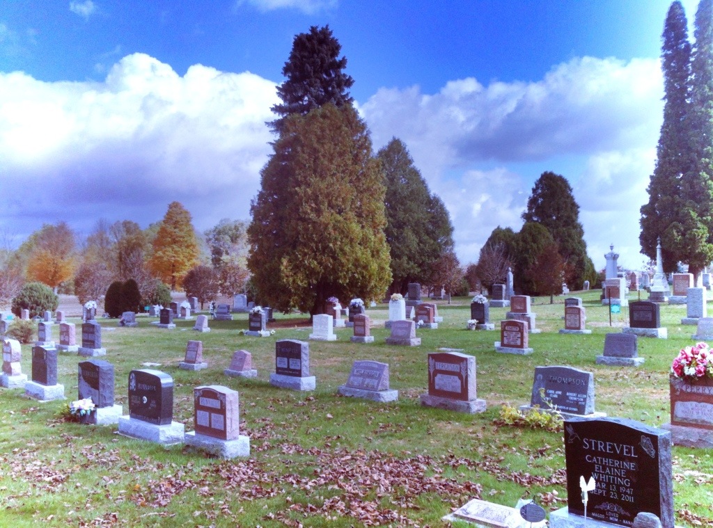
I spent a lot of time with Ruth in the location from which this image was taken. Today had not started out all that great. I am feeling the pressure to get all my stuff in order before launching the road trip and stress is no longer my thing. So sitting here on an extremely pleasant day sipping coffee and wolfing down sorbet while awaiting my scans had a relaxing effect on me. I tried a few versions of this image as a panorama but ultimately decided on what you see. This was captured with an iPhone and edited with an app called Mobile Monet. I’ve used it for some previous posts and enjoy the effect. It could not have been a much better day weather wise but if it had been, it would have looked just like this. Believe me.